Portugalis situated in the extreme southwest of Europe and includes the Madeira and Azores archipelagos in the Atlantic Ocean. On the European continent, the Portuguese territory occupies an area of 88,889 km2 (218 km wide, 561 km long, 832 km of Atlantic coast, and 1,215 km of land border with Spain). Located in the Atlantic Ocean, between the European and North American continents, the Azores archipelagohas an area of 2,355 km2 and is made up of nine islands - São Miguel and Santa Maria in the Oriental Group, Terceira, Graciosa, São Jorge, Pico and Faial in the Central Group, and Flores and Corvo in the Western Group. Connections with mainland Portugal are ensured by air, in around 2 hours of flight time. The Madeira Archipelago, with an area of 741 km2, is located in the Atlantic Ocean, approximately 500 km from the African coast and 1,000 km from the European continent (1h30 flight to Lisbon). It is made up of the Islands of Madeira and Porto Santo, and the uninhabited islands of Desertas and Selvagens (which are Natural Reserve Areas).
The Azores( Portuguese: Açores) officially the Autonomous Region of the Azores (Região Autónoma dos Açores), is one of the two autonomous regions of Portugal (along with Madeira). It is an archipelago composed of nine volcanic islands in the Macaronesia region of the North Atlantic Ocean, about 1,400 km (870 mi) west of Lisbon, about 1,500 km (930 mi) northwest of Morocco, and about 1,930 km (1,200 mi) southeast of Newfoundland, Canada.
The Azores are the seventh most populous Portuguese region, with 236,413 inhabitants (2021 census), they are the fourth largest Portuguese urban area, with a population density of 101.8 inhabitants/km² and they are the sixth largest Portuguese region, with a total area of 2,322 km².
Administratively, the Azores are subdivided into 19 municipalities and 155 parishes. The Azorean island of Corvo (whose territory forms a municipality) has the particularity of being the only portion of Portugal's national territory that is not integrated into any parish.
Geographic location
The Azores are an archipelago that, although located precisely on the Mid-Atlantic Ridge, due to its proximity to the European continent and its political integration in the Portuguese Republic and the European Union, is generally included in Europe.
The archipelago is located in the northeast of the Atlantic Ocean between 36º and 43º North latitude and 25º and 31º West longitude. The nearest territories are the Iberian Peninsula, approximately 1,400 km to the east, Madeira, 930 km to the southeast, Saint Pierre and Miquelon to the northwest, 2,200 km, Nova Scotia, 2,400 km to the northwest, and Bermuda 3 100 km southwest. It is part of the Macaronesia biogeographic region. The geographic coordinates of the main locations in the Azores are as follows:
Location
Vila do Corvo
39º 40.1' 31º 06.5'
Santa Cruz das Flores
39º 27.2' 31º 07.2'
Lajes das Flores
39º 22.6' 31º 09.9'
Santa Cruz da Graciosa
39º 05.0' 27º 59.9'
Praia da Vitória
38º 43.9' 27º 03.5'
Velas
38º 40.8' 28º 12.3'
Angra do Heroísmo
38º 39.0' 27º 13.4'
Calheta
38º 36.0' 28º 00.7'
Vila do Topo
38º 32.5' 27º 45.6'
Horta
38º 32.0' 28º 37.3'
Cais do Pico
38º 31.7' 28º 19.2'
Lajes do Pico
38º 23.9' 28º 15.4'
Ponta Delgada
37º 44.1' 25º 40.3'
Ilhéus das Formigas
37º 17.0' 24º 53.0'
Vila do Porto
36º 56.7' 25º 08.9'
Territory
The Azores archipelago is made up of nine main islands divided into three distinct groups:
Western Group
Corvo
Flores
Central Group
Faial
Graciosa
Pico
São Jorge
Terceira
Eastern Group
Santa Maria
São Miguel
They extend for more than 600 km (370 mi) and lie in a northwest–southeast direction. All of the islands have volcanic origins, although some, such as Santa Maria, have had no recorded activity in the time since the islands were settled several centuries ago. Mount Pico, on the island of Pico, is the highest point in Portugal, at 2,351 m (7,713 ft). If measured from their base at the bottom of the ocean to their peaks, which thrust high above the surface of the Atlantic, the Azores are among the tallest mountains on the planet.
Climate
The climate of the Azores is very mild for such a northerly location, being influenced by its distance from the continents and by the passing Gulf Stream. Because of the marine influence, temperatures remain mild year-round. Daytime temperatures normally fluctuate between 16 and 25 °C (61 and 77 °F) depending on season. Temperatures above 30 °C (86 °F) or below 3 °C (37 °F) are unknown in the major population centres. It is also generally wet and cloudy.
Geostrategic importance
Their location in the central area of the North Atlantic meant that the Azorean islands constituted an authentic crossroads on transatlantic routes for centuries.
To understand the position of the archipelago, pay attention to the following distances measured along the orthodrome (great circle) from a point located in the geographic center of the Azores (38º 35' N; 28º 05' W):
Funchal, Madeira — 1,206 km;
Lisbon — 1,643 km;
Mizen Head, Ireland — 2,011 km;
Cape Race, Newfoundland and Labrador, Canada — 2,253 km;
London — 2,595 km;
Praia, Cape Verde — 2,668 km;
Paris — 2,673 km;
Reykjavik, Iceland — 2,871 km;
Hamilton, Bermuda — 3,371 km;
Boston, Mass, USA — 3,618 km;
New York, N. I, USA — 3,889 km;
João Pessoa, PB, Brazil — 4,994 km;
Brasília — 6,385 km.
Economic sectors
Agriculture
The volume of milk production received at the factories is around 500 million liters. Industrialized milk is consumed predominantly in the UHT form.
Cheese represents the most significant dairy product, registering positive evolution, even in years of raw material reduction.
Meat production has registered, in recent years, a positive trend. The direction of this evolution is common to different types of meat. However, the intensity is due, fundamentally, to beef for export, whose growth is bringing it closer to the levels reached before the 1997 crisis. The evolution in the growth of meat for consumption on the islands themselves is characterized more by moderation and regularity.
Fisheries
Fishing activity, measured by fish landed in ports, translates into volumes of around 10,000 tonnes per year, which correspond to gross production values of around 26 million euros. Each year, specific variations are recorded in the conditions under which activities are carried out in the sector, with significant price fluctuations being observed.
The different varieties of more traditional fish («remaining fish» in the table below) occupy the most representative place, with the tuna fishing component being the one that is most sensitive to production conditions.
The number of registered fishermen is around 4 thousand and the number of vessels is around 1,600 units. Seeking to observe the current trend of evolution of these productive factors, through some indices, a trend towards an increase in size measured by the average tonnage per vessel and per registered fisherman will be verified.
In 2004, the traditional hotel industry, plus tourism in rural areas added up to an accommodation capacity of around 8,000 beds, as a result of a notable growth in the supply of tourist accommodation, which was felt essentially in the last four years. .
Demand has systematically increased every year, both in terms of overnight stays and in terms of revenue. From 1996 to 2004, the number of overnight stays grew by 124% and total revenues by 148%.
Today, more than 50% of the hotel supply has been built again and the remaining part has been, more than 50%, deeply remodeled and restructured.
From 1996 to 2004 there was a significant jump in market demand. Portugal, in 1996, represented 71% of the total volume of overnight stays, while in 2004 it represented only 51%.
It is clear that although tourism promotion in Portugal is always a dominant concern, with the increase in hotel supply and given the strong seasonality of the national market, it becomes increasingly important to diversify demand. In 2004, the Swedish market represented 16% of demand, followed by the Norwegian market with around 8.3% and the German market with 7.1%.
Since 2015, and after the liberalization of airspace, which allowed Ryanair and Easyjet (currently only Ryanair flies to the islands of São Miguel and Terceira) — lowcost air carriers — the Azores destination has become more accessible and popular. It is currently one of Brazilians' favorite vacation destinations. "The liberalization of domestic air transport to the Azores, which occurred at the end of the first quarter of 2015, the investment in promotion that has been carried out and the improvement of inter-island accessibility, have effectively contributed to this growth".
Industry
The evolution of manufacturing industries, observable through company statistics, points towards a growth process accompanied by changes in production structures, at least in terms of size.
In fact, at the same time that revenue has registered, in recent years, growth intensities at significant levels, the number of companies and employed people, on the contrary, has been decreasing. Given that in the process of decreasing these productive elements, the number of personnel was proportionally higher than that of the companies themselves, there was, logically, an increase in the average size of the respective structures.
Despite this evolution, the average size of companies in the manufacturing industries remains smaller than the average of companies in the Portuguese economy. In fact, according to the latest data, the average number of people employed per production unit in the Azores was 10 workers per company, while the same ratio, at country level, reached 12.
The reduced size is also observable in terms of the average turnover of industrial companies, whose profitability is more dependent on the margins that are possible in terms of cost reduction.
Energy
The primary energy sources used continue to be based on imported fossil fuels (fuel, diesel, gasoline). However, renewable energy sources such as hydropower, geothermal energy and wind energy have recorded positive developments, approaching in recent years approximately one tenth of the total energy consumed.
Electricity production has grown at significant rates, with the respective annual average rates standing at around 7%.
Thermal production continues to be dominant, but renewable energies already represent a share of close to a fifth of the total.
With regard to electricity use, domestic consumption represents the most significant component, but commercial and service consumption has been more dynamic in recent years. Industrial consumption has been characterized by a certain stability, just following the general average evolution of recent years.
Construction and housing
In recent years, local cement production contributed around 55% of the total cement used in works. In previous years it had a share of around 60%.
Housing works licenses represent around three quarters of the total licenses granted for works in the Azores.
Business
In the commercial sector, there was an evolution with growth in activity based more on the creation of new service units than on increasing capacity and modernizing existing ones. In fact, statistical data points to significant growth in revenue, at the same time as the number of companies and employed people grows.
In fact, the intensity of growth in the number of employed persons was very close to that of the growth in the number of companies, with the ratio of personnel per company remaining practically constant. This index of around 5 people employed per company confirms the strong presence of small business units and the atomistic nature of this type of services.
Given the characteristics of the commercial sector, in national terms, the differences between structures in different regions will result more from small differences in evolution and circumstantial adaptations, than from structural factors such as size that are more evident in material and industrial production organizations.
Sales of new cars in 2004 showed positive behavior, reversing the previous trend. In 2004, passenger car sales in the Azores represented around 77% of total new car sales.
Transport and communications
Available data on passenger movements point to a trend towards a reduction in traffic in public land transport and an increase in sea and air transport. Passenger movements at airports have revealed changes in their composition according to the different types of traffic.
Internal passenger traffic (in practice between islands) still records the highest number of frequencies, but it no longer has the predominance it usually had and in 2002 and 2003, it represented percentages of less than half of total traffic.
On the other hand, traffic with abroad (territorial and international), despite remaining more sensitive to economic influences, shows higher growth trends on average. This will be particularly the case for international traffic, which is consistent with the evolution of tourist demand.
Observing the frequency of passenger movements at airports in relation to the number of resident inhabitants, it can be seen that in the Azores there is a high intensity in the use of air transport, when compared with the Mainland using the same indicator. This difference in intensity will be logically related to the different characteristics of the physical geography in both territories.
Cargo handled at ports reaches around 2.7 million tons, however the volume handled at airports does not represent 1% of that.
Postal traffic is at a level of around 10 million objects, while the number of existing payphones continues to grow more intensely.
São Miguel Island nicknamed "The Green Island" (Ilha Verde) is the largest of the islands in the Azores archipelago and the largest of all the islands that make up the territory of Portugal. With an area of 748.82 km², it measures 64.7 kilometers in length and 8–15 km in width and has a population of 137,699 inhabitants (2011).
It comprises the municipalities of Lagoa, Nordeste, Ponta Delgada, Povoação, Ribeira Grande and Vila Franca do Campo.
On the Island of São Miguel there are 64 parishes:
Achada; Achadinha; Água de Alto; Água de Pau; Água Retorta; Algarvia; Ajuda da Bretanha; Arrifes; Cabouco; Calhetas; Candelária; Capelas; Conceição; Covoada; Faial da Terra; Fajã de Baixo; Fajã de Cima; Fenais da Ajuda; Fenais da Luz; Feteiras; Furnas; Ginetes; Livramento; Lomba da Fazenda; Lomba da Maia; Lomba de São Pedro; Maia; Matriz; Mosteiros; Nordeste; Nossa Senhora dos Remédios; Nossa Senhora do Rosário; Pico da Pedra; Pilar da Bretanha; Ponta Garça; Porto Formoso; Povoação; Rabo de Peixe; Relva; Remédios; Ribeira Chã; Ribeira das Tainhas; Ribeira Quente; Ribeira Seca (Ribeira Grande); Ribeira Seca (Vila Franca do Campo); Ribeirinha; Salga; Santa Bárbara (Ribeira Grande); Santa Bárbara (Ponta Delgada); Santa Clara; Santa Cruz; Santana; Santo António; Santo António de Nordestino; São Brás; São José; São Miguel; São Pedro (Ponta Delgada); São Pedro (Vila Franca do Campo); São Pedro de Nordestino; São Roque; São Sebastião; São Vicente Ferreira; Sete Cidades.
Transport
Three bus routes operate in Ponta Delgada on weekdays from 07:00 to 19:00. Line A runs in the western part of town, line B in the central/north, and line C in the east. There are bus services between Ponta Delgada and most other towns on the island, but usually only a few times a day. City services and island-wide services are both accessible along "Avenida D. Infante Henriques" and conveniently accessible from major sites in Ponta Delgada. Up to date schedules are available at bus stops and the tourist office. Distances on the island are short with journeys rarely longer than 90 minutes.
Joao Paulo II Airport (Ponta Delgado Airport) provides airline connections to all of the islands of the Azores as well as to Madeira and the mainland (namely, Lisbon, Porto, and Faro) as well as numerous international destinations in Europe and North America.
Climate
São Miguel has a mild maritime climate, which is drier in the summer and wetter in the winter, though according to the Köppen climate classification, four different climatic classifications can be found throughout the island. At lower elevations, the hot-summer Mediterranean climate (Csa) dominates over the Humid subtropical climate (Cfa) typical of the more westerly islands and truly only found around Capelas. Above 100 m (330 ft) altitude, the Mediterranean climate transitions into its warm-summer variant (Csb), and past 200 m (660 ft) the climate is strictly oceanic (Cfb).
The western half of the island is generally drier, due to the lower topography. Precipitation varies from less than 800 mm (31 in) in the Northwest coastline between Mosteiros and Ajuda da Bretanha, to over 3,200 mm (130 in) around Pico da Vara in the east.
Similar to other islands in the archipelago, São Miguel is influenced by ocean currents and winds, and, in particular, the cyclonic Gulf Stream. This stream functions as a moderating force in the islands, keeping temperatures hovering between 14 °C (57 °F) and 23 °C (73 °F) throughout the year. The island's location also makes it susceptible to some Atlantic storms, and precipitation tends to be elevated during the winter periods. Winters are very mild by European standards and summers are warm (sometimes very warm due to the high humidity) and relatively dry. Temperatures above 30 °C (86 °F) or below 5 °C (41 °F) have never been recorded at the coast.
NATURE
Lagoa das Sete Cidades – Place of legends and myths, the Lagoa das Sete Cidades takes a certain mystique due to its idyllic landscape often accompanied by mist. It stands as the most iconic Crater Lake on São Miguel Island.
Lagoa do Fogo – Great place for a pedestrian trail. With vegetation that only exists in its volcanic extent, this lake has a wilder side comparing to others, making the descent to its base a mandatory stop.
Lagoa das Furnas – Located in Furnas Valley, this lake is in an easy access place, which means that anyone can go for a visit. Lake with great extent and lush surrounding vegetation. It's in its margins that the famous Furnas meat stew can be baked.
Parque Terra Nostra – A magnificent botanical garden with a wide variety of endemic species and many others. With one of the most impressive collections of camellias in the world, Parque Terra Nostra is without a doubt a unique place, especially to nature lovers.
Caldeira Velha – Situated in Ribeira Grande, on the way to Lagoa do Fogo, Caldeira Velha is an excellent option for those who want to have a relaxing bath in the typical thermal waters of the Azores.
Heritage
Portas da Cidade – Built in the eighteenth century, they are considered the ex-libris of the city of Ponta Delgada. This monument consists of a set of three round arches, built in regional stone, presenting a contrast between white and black basalt, a typical characteristic of the island of São Miguel.
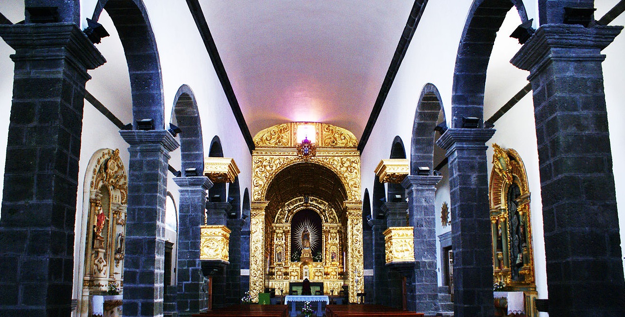
Igreja de São Sebastião – Best known for Matriz, this church was built between the years 1533-1545 as a promise of the inhabitants of São Miguel Island to São Sebastião to end an epidemic. After several renovations, the Gothic styled church presents today Manueline and Baroque elements, being built with limestone and basalt from the island.
Igreja do Colégio – Former residence of the Companhia de Jesus, the Igreja do Colégio now houses the Museu Carlos Machado’s Núcleo de Arte Sacra. Containing paintings and sculptures of the seventeenth and eighteenth centuries in its assets, it presents itself today as a cultural space, with a large shed for education and knowledge.
💓💓💓💓💓
SANTA MARIA ISLAND
36° 58′ 29″ N; 25° 05′ 41″ W
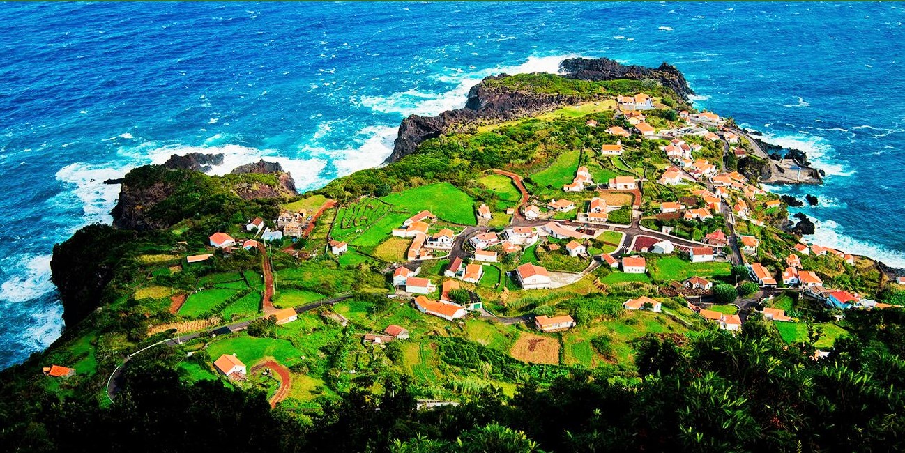
Santa Maria is an island in the eastern group of the Azores archipelago (south of the island of São Miguel) and the southernmost island in the Azores. The island is known for its white sand beaches, distinctive chimneys, and dry warm weather.
It has an area of 97.4 km² and a resident population (gentile: Marienses) of 5 578 inhabitants (2001), distributed among the five parishes that make up the municipality of Vila do Porto, the only one on the island.
It would have been the first island in the Azores to be sighted, around 1427, by the Portuguese navigator Diogo de Silves. Later, in February 1493, Christopher Columbus stopped at the island on his return from his first voyage to America.
Currently, the main economic engine of the island is the aeronautical activity, with the Santa Maria Airport and the Centro de Controle Aéreo do Atlântico, which manages the FIR Oceânica de Santa Maria, one of the largest and most important regions of flight information in the world. world.
Geography
Located about 100 km south of the island of São Miguel and about 600 km from the island of Flores, Santa Maria is the easternmost and southernmost island of the archipelago. It lies between the parallels 36º 55' N and 37º 01' N and the meridians 25º00' W and 25º 11' W. It has a roughly square shape and, with the maximum length of the respective diagonal of around 15.5 kilometers, between point of Castelo and to the Southeast and the tip of Restinga, to the Northwest.
Geologically, it is the oldest island in the Azores, with formations that are over 8.12 million years old, making it the island with the most remote volcanism. This comparatively advanced age gives maturity to the relief and explains the presence of extensive formations of sedimentary origin where marine fossils can be found.
Although it is the only one in the archipelago that does not show recent volcanic activity, it is also subject to relatively high seismicity given its proximity to the final section of the Falha Glória (Azores-Gibraltar fracture zone).
With only 97.4 km² of surface area, it has a roughly oval shape, with a maximum length in the northwest-southeast direction of 16.8 km, the island is divided into two regions with a sharply contrasting geomorphological aspect.
History
Colonization progressed between 1443 and 1447, principally from settlers from the Portuguese Alentejo and Algarve, who populated the northern coast along the Baía dos Anjos (English: Bay of the Angels) and later in the area of Vila do Porto (in the southwest coast).
During World War II the United States used Santa Maria Airport (Azores) as a base.
On 8 February 1989, an American chartered Boeing 707 of Independent Air Flight 1851 crashed at Pico Alto, killing all 137 passengers and 7 members of the crew. There was confusion between tower and pilots as to the appropriate altitude during their approach.
Climate
Santa Maria has a mild Mediterranean climate (Köppen: Csa). The island as well as the whole archipelago has an extremely moderate subtropical climate due to its location in the Atlantic Ocean influenced by the Gulf Stream. In the summer it is generally dry and warm. In winter, temperatures remain very mild, the bulk of the year's precipitation falls in this season, though Santa Maria is much drier than the rest of the islands, having less than half the precipitation of the more westerly Flores Island. Temperatures average 18.5 °C (65.3 °F) in the coast and around 14.5 °C (58.1 °F) in the easterly mountains. The "sunny island of the Azores", as its nickname suggests, receives on average around 2000-2200 hours of sunshine which is a considerable amount for the relatively dull archipelago it is in, though not a lot when compared to other places at the same latitude (like the Algarve in mainland Portugal). The mountain range east of the island and the northeast coast are much more humid, reaching in some locations values as high as 1,800 mm (71 in) of precipitation per year.
Measurements have been taken at the Santa Maria Airport since 1943/1944, initially managed by British or US air forces serving there. Later, another meteorological station was placed in the Recreational Forest Reserve of Fontinhas.
Politically, the island is one municipality, Vila do Porto, with a population of 5,578 inhabitants (2001), divided into five parishes:
Vila do Porto: includes one-third of the island, covering the western plain, the airport and local communities such as Anjos and Santana, encompassing 2,997 of the island's citizens.
São Pedro: the northern parish, it includes the communities of Fátima, Paul and Pilar: 841 inhabitants (2001)
Almagreira: the southern dry zone and transitional space that includes Praia Formosa and parts of the mountainous areas of Monteiro and Bom Despacho: 537 inhabitants (2001)
Santo Espírito: the eastern corner covering Maia, Glória and Fontinhas: 723 inhabitants (2001)
Santa Bárbara: the northern and eastern parish that includes Lagoínhas, Norte and the São Lourenço: 480 inhabitants (2001).
Tourism
Tourists generally favour the white sand beaches and rock pools in the communities of Anjos (Vila do Porto), Praia Formosa (Almagreira), Maia (Santo Espírito) and São Lourenço (Santa Bárbara). Praia Formosa, in particular, is known on the island for its white sand beach that stretches across the bay. In the remaining locales, the original natural rock pools have been replaced by concrete pools with seawater access.
💓💓💓💓💓
TERCEIRA ISLAND
38° 43′ 40″ N; 27° 12′ 48″ W
Terceira is a volcanic island in the Azores archipelago, in the middle of the North Atlantic Ocean. It is one of the larger islands of the archipelago, with a population of 53,311 inhabitants in an area of approximately 396.75 square kilometres (153.19 square miles). It is the location of the Azores' oldest city, Angra do Heroísmo, the historical capital of the archipelago and UNESCO World Heritage Site. The island has two main sea ports, one at Angra do Heroísmo and the other at Praia da Vitória, and a commercial airport.
Within the municipal framework, communities are subdivided into local civil parishes (19 in Angra do Heroismo and 11 in Praia da Vitória), and managed by the executive (that includes a President and cabinet) and the civil committee (with its chairperson and assembly) of the Junta Freguesia.
Agualva; Altares; Biscoitos; Cabo da Praia; Cinco Ribeiras; Doze Ribeiras; Feteira; Fonte do Bastardo; Fontinhas; Lajes; Nossa Senhora da Conceição; Porto Judeu; Porto Martins; Posto Santo; Quatro Ribeiras; Raminho; Ribeirinha; Santa Bárbara; Santa Cruz; Santa Luzia; São Bartolomeu de Regatos; São Bento; São Brás São Mateus da Calheta; São Pedro; Sé; Serreta; Terra Chã Vila de São Sebastião; Vila Nova.
Angra do Heroísmo, the historical capital of the Azores (Açores), is the oldest city in the archipelago, dating back to 1534. Owing to the importance of the historical center in the "maritime explorations of the 15th and 16th centuries", UNESCO declared the historical center as a World Heritage Site. This was, in part, due to the fact that, as a link between the New World and Europe, Vasco de Gama, in 1499, and Pedro de Alvarado, in 1536, set up Angra as an obligatory port-of-call for the fleets of equatorial Africa and of the East and West Indies. The classification by UNESCO was based on criteria 4 and 5 that governed the inclusion based on universal historical significance (based on its place in the exploration).
💓💓💓💓💓
PICO ISLAND
38° 27′ 57″ N; 28° 20′ 0″ W
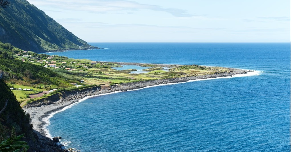
Pico Island is an island in the Central Group of the Portuguese Azores. The landscape features an eponymous volcano, Ponta do Pico, which is the highest mountain in Portugal, the Azores, and the highest elevation of the Mid-Atlantic Ridge. In the tradition of the Portuguese poet, Raul Brandão, Pico is referred to as the Ilha Preta ("Black Island"), for its black volcanic soils, which nourish its UNESCO-designated vineyards that once allowed the development of the island's economy. Pico is the second largest and, geologically speaking, the most recently formed island of the Azores, being around 300,000 years old.
The island is 17.5 km south of São Jorge and just 7 km east of Faial, in the Central Group of islands, an area that is colloquially known as O Triângulo (The Triangle). Pico is 46.3 kilometers long, and at its maximum extent about 16 kilometers wide; making it the second largest of the Azores islands. The 151.8 km coastline is slightly indented with inlets and coves. Accessibility to the sea poses no difficulties, except in sections with plunging, unstable cliffs, subject to frequent landslides (as seen in the northeast and southeast). Seabirds find favorable conditions for nesting in these habitats, in particular the species of Tern (Sterna hirundo and Sterna dougallii) and Shearwater (Calonectris borealis). The rocky substrates prevail throughout the coast (slabs that alternate with rolled pebbles), there are no sandy beaches, but there are numerous tide pools and natural inlets used for bathing.
Earthquakes
Pico, much like the other islands, is susceptible to seismic events, although their epicenters have primarily been localized in the Faial-Pico or Pico-São Jorge Channels. Only three significant tectonic earthquakes have hit the island of Pico since the beginning of settlement: The 1757 earthquake, which caused significant damage in the eastern region of the island including the death of 11 people and the collapse of a church and a few houses; the 1973 seismic crisis (October 1973 - May 1974) in which the main earthquake (with magnitude 5.5) did considerable damage to 604 houses in Faial and 2,000 in Pico, which left nearly 5,000 people homeless; and the July 9, 1998 earthquake, the strongest earthquake registered in the last 30 years, which had its epicenter 5 kilometers northeast of Ponta da Ribeirinha, on the island of Faial, reaching a 5.8 magnitude. It was felt on Pico, with a maximum intensity level of VII on the Mercalli scale; some homes were damaged and possessions were buffeted. Other violent earthquakes which have affected the island include: the 1957-58 seismic events associated with the eruption of the Capelinhos volcano (on Faial), the February 1964 earthquake on the island of São Jorge, and the 1926 earthquake, whose epicenter was registered in the Faial-Pico Channel.
Climate
Pico, like the remaining islands of the archipelago, has a mild maritime climate with high precipitation for most of the year, high humidity and constant winds. However, due to its unusual topographic variation, temperature and precipitation levels vary significantly depending on both altitude and location (generally, rainfall is more concentrated in the east). Temperatures vary around 8 °C between the coolest and the warmest month (February and August respectively)
At lower elevations, where most of the population resides, Pico has a humid subtropical climate (Köppen: Cfa; Thornthwaite: B) with mild, rainy winters (mean around 14.5 °C (58.1 °F)) and warm, noticeably drier summers, (mean around 22 °C (72 °F)) although generally not dry enough to be classified as Mediterranean. It has an average annual temperature of 17.5–18 °C (63.5–64.4 °F) and around 1,000 to 1,600 mm (39 to 63 in) of precipitation fall each year, though values as high as 2,000 mm (79 in) are typical on the central northeast coast (São Roque, Prainha and Santo Amaro). Because of its high relative humidity (around 80%), summers can feel slightly warmer than they really are.
At higher elevations, like the Achada Plateau, temperatures are cooler and precipitation increases, it therefore transitions into a wet oceanic climate (Köppen: Cfb; Thornthwaite: A), average relative humidity stays around 90% and fogs produced by the cooling of rising air masses from the ocean are persistent, which, in turn, creates an environment typical of a cloud forest. Places such as the Caiado and Paul lakes receive, respectively, 4,698 and 3,357 millimetres (185.0 and 132.2 in) of precipitation each year and Mount Pico is recognized as receiving the largest annual rainfall in Portugal (over 5,000 mm (200 in) per year at the northeastern flanks of the volcano).
At around 1,200 m (3,900 ft), the climate becomes subpolar oceanic (Cfc) (somewhat comparable to the Faroe Islands). As altitude surpasses 1,500 metres (4,900 ft) and exceeds the planetary boundary layer, both precipitation and humidity levels decrease reaching the top of Mount Pico which averages only around 500 millimetres (20 in) of precipitation. Temperatures at the peak of the stratovolcano (~2,300 metres (7,500 ft) a.s.l.) average 2 °C (36 °F) and snow can be frequently seen in the cooler months, one of the few places in the archipelago where this phenomenon is possible. The climate is classified as alpine at the very top.
Pico has registered the highest temperature ever recorded in the Azores, 32.1 °C (89.8 °F) on 7 September 1985 at Pico Airport and although there are no climatic stations at Mount Pico, it is likely that the island has also experienced the lowest temperatures in the archipelago at the top of the mountain.
💓💓💓💓💓
FAIAL ISLAND
38° 34′ 57″ N; 28° 42 ′17″ W
Faial Island, also known in English as Fayal, is a Portuguese island of the Central Group (Portuguese: Grupo Central) of the Azores.
The Capelinhos Volcano, the westernmost point of the island, may be considered the westernmost point of Europe (if the Monchique Islet, near Flores Island, is considered part of North America, since it sits on the North American Plate). Its largest town is Horta.
With its nearest neighbours, Pico (east across the channel) and São Jorge (northeast across the channel), it forms an area commonly known as the Triângulo (English: Triangle). The island has also been referred to as the Ilha Azul (English: Blue Island), derived from the writings of Portuguese poet Raul Brandão, due to the large quantity of hydrangeas that bloom during the summer months.
The island, dependent on whaling and agriculture, remained prosperous until the eruption of Capelinhos volcano in 1957. Communities of the northern and western coast were harshly affected by the eruption, as agricultural lands were untillable and covered with sand and ash. This led to the migration of 4,000 people to the United States, spearheaded by members of the Portuguese diaspora in New England and Massachusetts Senator John F. Kennedy. In addition, whaling, as a viable commercial enterprise was slowly curtailed with innovations in the chemical sector and the influence of animal-rights groups.
Economic and political changes since the 1980s have helped to revitalize the island's economy and development. After the Azores gained the status of an Autonomous Region within Portugal, Horta, the island's only city, hosted the Regional Parliament (Parlamento Regional) of the Azores.
Geography
Physical geography
Along with other islands in the Azores archipelago, Faial is of volcanic origin, being one of the most volcanically active islands of the archipelago, and is close to the tectonic divide between the European and North American Plates. The island can be considered (from a geophysical perspective) the westernmost point of Europe (the two islands west of Faial, Flores and Corvo, are already on the American plate).
Visually, the island is characterized as an irregular pentagon, that occupies an area of approximately 173 square kilometres (67 sq mi), and formed along a leaky transform fault extending from the mid-Atlantic Ridge to the Hirondella faults. This is the same fault that bisects the remainder of the Central Group of islands along a west-northwest to east-southeast orientation. Although formed by complex volcanological events, the current landmass is dominated by the crater of its central stratovolcano with relatively gently sloping flanks, showing little sign of major erosion.
Climate
Faial has a humid subtropical climate with some Mediterranean influences, oceanic at higher altitudes. Average temperature is around 17–18 °C (63–64 °F), 20 °C (68 °F) at daytime and 15 °C (59 °F) at nighttime. It has very mild winters for its latitude, in part due to its location in the mid-Atlantic Ocean and infuence from the Gulf Stream, averaging 14 °C (57 °F) in its coldest month, February, and frosts never occur other than at high altitude. For comparison, Ocean City, Maryland, at a similar latitude, is 11.4 °C (52.5 °F) colder in its coldest month, averaging only 2.6 °C (36.7 °F). Summers are warm and relatively dry. Temperatures are moderated year-round, never too hot or too cold, daily temperatures are also moderated, with only 5 °C (41 °F) difference between highs and lows. Average relative humidity remains high at around 80% and insolation is relatively low with around 1800–1900 hours of annual sunshine, similar to locations in coastal northwestern Europe such as Nantes, France, although the sun is stronger in Faial because of its lower latitude. Precipitation is plentiful especially in the winter months, averaging 1,000 mm (39 in) annually. At higher altitudes (e.g. Caldeira Volcano) temperatures are cooler, precipitation and humidity are increasingly higher, and fog is very common.
Human geography
Administratively, the island is governed as one municipality, with its government seat in the city of Horta. Operationally, there are thirteen civil parishes with their own assemblies, three of which (Angústias, Matriz and Conceição) constitute the principal urbanized core:
Angústias; urban parish that includes the escoria cones of Monte da Guia, Monte Escuro and Monte Carneiro, as well as the island's hospital, the major hotels, commercial and container port, and many historical buildings (such as the Fort of Santa Cruz, The Cedars, and the Church of Nossa Senhora das Angústias): 3,025 inhabitants (2003).
Conceição; urbanized and rural parish connected to the city of Horta, with 1,157 inhabitants in 2001. It was one of the nuclei of the modern city of Horta, location of the historic forts of Alagoa and Bom Jesus, and location of the Courts building and Fayal Sport Club (and football field).
Matriz; the urban heart of the city of Horta, with 2,523 inhabitants (2001); landmarks include the Horta Museum, Sociedade Recreativa Amor da Pátria, Império dos Nobres, the historic Clock Tower, the former Walter Bensaúde Hospital and the Horta Archive and the Public Library, as well as the location of the Municipal Government (Câmara Municipal da Horta).
The remainder of the parishes (except Flamengos) circle the island, all linked by the regional road network and its ancillary roads:
Flamengos; one of the first nuclei of settlement and colonization, and the only interior/landlocked parish in the municipality of Horta founded by Flemish colonists and Portuguese settlers from the archipelago.
Praia do Almoxarife; the beachhead of the early colonists to Faial, Almoxarife is a coastal parish on the east coast, located between Ponta da Espalamaca and Lomba dos Frades, and is known for its black sand beach.
Pedro Miguel; located on the eastern coast between Lomba dos Frades and Lomba Grande, its 723 inhabitants lost their primary place of worship, the Church of Nossa Senhora da Ajuda, during the 1998 earthquake.
Ribeirinha; nestled in the river valley of the Pedro Miguel Graben and existing along the fracture zone of the Ribeirinha Volcanic complex alon the north-northeast coast, Riberinha has experienced many seismic events historically.
Salão; the smallest parish by population situated on the northern coast of Faial, a community built by Spanish settlers, that were later expelled following the end of the Iberian Union.
Cedros; built on the coastal cliffs of the Cedros Plateau along the northern coast, it is the oldest parish on Faial, involved in agriculture and dairy industry (and the location of the milk cooperative C.A.L.F).
Praia do Norte; a zone of recent historical volcanism, built on layers of ash and pyroclastic deposits, the parish became "extinct" between 1672 and 1845, following the eruption of Cabeço do Fogo, which depopulated the parish. Emigration also occurred following the eruption of Capelinhos in 1957–58.
Capelo; a parish built along a linear series of volcanic cones, culminating in the 1957–58 eruption of Capelinhos off the western coast. The crisis caused the implementation of an immigration program spearheaded by Senator John F. Kennedy, that reduced the population of Faial and Capelo.
Castelo Branco; location of the international airport, its 1,115 inhabitants are involved in a mix of agricultural and enterprises associated with primary and secondary industries along the southern coast that includes the micro-climate of Varadouro.
Feteira; a parish dominated by agriculture, the inhabitants are equally tied to the commercial activities in Horta, developing into a suburb of the larger city.
Faial has been affected by various earthquakes and seismic events during its populated history. The most important were the 1759–1760 earthquakes and aftershocks that occurred around Christmas and New Year. Similar in nature, the 1926 earthquake which rumbled the city of Horta, in early-April, where damages were reported in Flamengos, Ribeirinha and Conceição. Then, on August 31 at 8:42, a new earthquake caused eight deaths and ruined buildings in Horta, as well as the parishes of Conceição, Praia do Almoxarife (ruining 220 homes), Flamengos, Feteira and Castelo Branco, Salao and most of the Lomba do Pilar. Approximately 4,138 homes and buildings were partially or totally damaged. Similar tremors and events were felt in 1957–1958 (Capelinhos eruption), then in 1963, and again in 1973. The 1998 Azores earthquake on July 9, which shook the islands of Faial, Pico and São Jorge at 07:19 (its epicentre north-northeast of Faial) measured 5.6 on the Richter scale and caused damages to the parishes of Riberinha, Pedro Miguel, Salão and Cedros and stronger damages in Castelo Branco (mainly Lombega), Flamengos and Praia do Almoxarife. Eight people died in the earthquake and 1,700 were left homeless.
💓💓💓💓💓
SÃO JORGE ISLAND
38° 37′ 40″ N, 28° 01′ 02″ W
The island of São Jorge is an island located in the center of the Central Group of the Azores archipelago, separated from the island of Pico by a 15 km strait - the São Jorge channel. The island is 53 km long and 8 km wide, with a total area of 237.59 km², and has a population of 9171 inhabitants (2011).
Geography
This island is crossed by a mountain range that reaches a maximum altitude of 1,053 meters, at Pico da Esperança. The coast is generally rocky, with high and steep cliffs.
The great particularity of this island are the Fajãs, almost all inhabited but very difficult to access. On the north coast, the Fajã do Ouvidor, Fajã da Caldeira de Cima, Fajã da Ribeira da Areia, Fajã dos Cubres and Fajã da Caldeira de Santo Cristo stand out. On the south coast, the most important are Fajã dos Vimes and Fajã de São João.
Its origin is linked to fissure volcanism promoted by the expansion of the Atlantic crust and is associated with a transform fault that runs from the CMA to the island of São Miguel - the Falha de São Jorge
This is how this island was created by successive volcanic eruptions in a straight line, of which craters remain, its central platform has an average altitude of 700 meters, often descending almost steeply from that altitude to the fajãs by the sea. Thus, some places have a highly craggy and almost vertical coastline, especially in the north. It is located at 28º 33' West longitude and 38º 24' North latitude.
The climate, like the rest of the islands in the Central group, is moderate, with average annual temperatures ranging between 12 °C (53 °F) and 25 °C (77 °F).
This island has a very elongated and very narrow profile, which makes it unique in the Azores archipelago, as no other island has a similar characteristic. It is an island whose mountains are very high on the slopes facing north, mainly due to the strong and constant abrasion of the sea and also because the sea is quite deep on this side of the island. These characteristics allowed the appearance of the fajã, which in the case of the island of São Jorge and due to its quantity is also unique in the Azores.
The south coast has a much less steep slope, descending almost smoothly to the sea. On this much lower coast, it is rare for fajãs to appear.
Regional tectonics contributed a lot to this morphology, which formed an alignment of strombolian cones originating from fissure volcanism.
Meteorology
São Jorge is located in the middle of the Atlantic Ocean in an area of high atmospheric pressure, benefiting from the influence of the Gulf Stream which, keeping the sea water temperature between 17° and 23°C and with atmospheric temperatures between 13° and At 24°C, it conditions the humidity of the air with an annual average of 75% and provides a rainfall pattern that helps shape not only the physical appearance of the landscape but also the beings that inhabit it.
Administratively, São Jorge is divided into two municipalities: Calheta in the east with five parishes and Velas in the west with six parishes. The rural population is basically aligned along the lines of communication divided by areas of unpopulated pastureland between localities.
Calheta Municipality
Parishes:
Calheta
Norte Pequeno
Ribeira Seca
Santo Antão
Vila do Topo
Velas Municipality
Parishes:
Manadas
Norte Grande
Rosais
Santo Amaro
Urzelina
Velas
There are three villages: Calheta, Velas and Vila do Topo.
💓💓💓💓💓
GRACIOSA ISLAND
39° 03′ N, 28° 01′ W
Graciosa is an island located in the extreme northwest of the Central Group of the Azores archipelago, 37 km northeast of the island of São Jorge and 60 km northwest of Terceira, centered approximately on geographic coordinates 28° 05' W and 39° 05' N. It has an approximate area of 60.66 km² and a roughly oval shape, with a length of 12.5 km and a maximum width of 7.5 km. It is the least mountainous of the Azorean islands, reaching a maximum altitude of 405 meters on the southern edge of the Caldeira. This low elevation gives the island a temperate oceanic climate, characterized by less rainfall in the archipelago. The low rainfall leads to the relative dryness of the island, which gives it a whitish tone at the end of the summer, which, associated with the white houses of the villages, gave it the epithet of Ilha Branca, which was attributed to it by Raul Brandão in the work As Ilhas Desconhecidas ( 1926).
It has 4,301 inhabitants (2021), mostly concentrated in the seat of the only municipality on the island, the town of Santa Cruz da Graciosa, whose historic center constitutes, due to the richness and balance of its architecture, a classified area. In the past, when the population was much higher than today, the lack of water was a serious problem, leading to the construction of reservoirs (tanks) and cisterns of various types and the emblematic tanks ("pauis") that are today the hallmark of the main square of Santa Cruz da Graciosa.
The landscape of Graciosa is of great beauty, combining the green of the pastures with the white of the isolated houses and villages. One of the "ex libris" of the island is a large rock formation, in front of the Ponta da Barca lighthouse, with a configuration very similar to a whale seen in profile. It has fertile and flat fields that produce maize, vegetables, fruit (mainly melon) and wine (from which a liqueur called andaia was produced) and where cattle are raised, today the main source of wealth on the island.
Geomorphology and geology
Graciosa is located at the northwest end of the tectonic structure called the Terceira rift, at the bottom of that area of the Atlantic Ocean, with a general southeast-northwest direction, coinciding with the general axis of the archipelago. This geological structure gave the island an elongated configuration along the axis of the rift, forming an ovoid 12.5 km long by 7.5 km at its maximum width.
The coastline, very rugged and cut by small calhetas, is generally low, with the exception of the northwest section, corresponding to Serra Branca, where the cliff exceeds 300 meters in height. On the coast there are two shallow bays, to the southeast is the bay of Praia, where the port of Vila da Praia, the island's commercial and fishing port, is located, and to the southwest is the bay of Filipe. To the northeast, in the area of Santa Cruz da Graciosa, there are some small calhetas, very exposed to the sea, where the port of Santa Cruz, today a bathing area, and the pier of Barra, former whaling and commercial port, now reduced to recreational facilities. nautical.
Climate
Graciosa has a mixed humid subtropical-Mediterranean climate (Köppen: Cwa-Csa) with mild to warm temperatures year-round, it is also one of the driest islands of the Azores owing it to its relatively low topography.
Human geography
The territory of Graciosa Island consists of one municipality, Santa Cruz da Graciosa (4,780 inhabitants in 2001), divided into four civil parishes:
Santa Cruz - the seat of the municipality and principal urbanized population on the island, located on eastern coast;
São Mateus da Praia - a historic village and once municipal seat, until it was unincorporated in the 19th century;
Guadalupe - the principal rural population on the island;
Luz - civil parish better known locally as "Sul" (South), located along the southern coast of the island.
💓💓💓💓💓
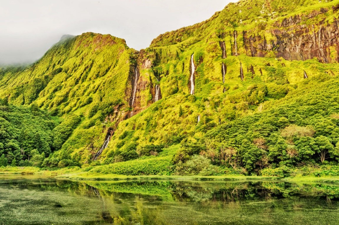
FLORES ISLAND
39° 26′3 7″ N; 31° 11′ 57″ W
The island of Flores is located in the Western Group of the Azores archipelago, on the North American Plate, being the largest of the islands that make up that group. It occupies an area of 141.7 km², mostly consisting of mountainous terrain, characterized by large ravines and gigantic cliffs. The highest point on the island is Morro Alto, at an altitude of 914 meters. The resident population is 3,793 inhabitants (2011), spread over the municipalities of Santa Cruz and Lajes das Flores. It is the westernmost point of Portugal (on Ilhéu de Monchique) and is often considered the westernmost point of Europe (if it is considered part of Europe, even if it is based on the North American Plate).
It is one of the most beautiful in the archipelago, covered with thousands of blue hydrangeas, which divide the fields along the roads, on the banks of streams and lakes.
UNESCO World Network of Biosphere Reserves
This island was included on the 27th of May 2009 in the UNESCO World Network of Biosphere Reserves list, joining the island of Graciosa and the island of Corvo which are also included in the list.
UNESCO emphasizes that this reserve includes the entire island, and that this fact is due to this island presenting aspects of a well-preserved nature where one can observe a great abundance of forest characteristic of the Laurisilva forests typical of Macaronesia, a landscape, geological, environmental and of great importance, and also adjacent marine areas. The UNESCO document also mentions the particularities of exceptional interest of the new classified site, namely the existence of “high escarpments that dominate most of the coastline, which is dotted with small islets”.
Climate
Under the Köppen climate classification, Flores Island has a humid subtropical climate (Cfa) that transits into an oceanic climate (Cfb) at higher elevations. Its climate is largely influenced by the warm Gulf Stream and the surrounding ocean, resulting in a narrow temperature range and a wet climate. Winters are very mild and rainy with a February average of 14.1 °C (57.4 °F). Summers are warm to hot with the average temperature in August averaging 25.7 °C (78.3 °F) during the day and 19.8 °C (67.6 °F) during the night. Throughout the year, temperatures rarely exceed 30 °C (86.0 °F) or fall below 5 °C (41.0 °F).
Precipitation is significant throughout the year, although summer months are drier than winter months. There are around 240 days with measurable precipitation. Humidity is constantly high (around 80% at sea level, increasing with altitude).
The microclimate of the forest park of Fazenda allows the development of a great number and variety of exotic species from all over the world.
Due to the generally rugged landscape of the island, many of the early settlements developed along the flatter coastal lands. The few settlements that are located in the interior are dotted by small homes or agricultural buildings.
Human settlement
Administratively, the island of Flores is divided into two municipalities (concelhos in Portuguese), which in turn are composed of several civil parishes, with their own civil committees and administrative executives:
Santa Cruz das Flores, located in the north, has 2,020 inhabitants (2021), and includes the island's largest community (Santa Cruz das Flores), a community located on the eastern coast, and where the local airport, as well as the principal governmental services, primary and secondary schools, and regional health centre are located. It comprises the following civil parishes:
Caveira, the smallest parish in size, bordering Lajes das Flores, with 76 inhabitants;
Cedros, the "middle" parish that straddles the river-valleys of Algoa Bay and historical location of orchards owing to its micro-climate;
Ponta Delgada; third-largest community on the island, located along the northern coast;
Santa Cruz das Flores; municipal seat, the location of the airport and largest population (with 1,552 inhabitants);
Lajes das Flores, the southern municipality includes many of the natural landscapes of the island and is inhabited by approximately 1,408 inhabitants (2021). The principal parishes are:
Fajã Grande, located in the basin and fajã on the western coast, with a population of 220 inhabitants;
Fajãzinha, with 71 residents, is located south of Fajã Grande; Fajãzinha is a diminutive of fajã, referring to it being a small agglomeration of homes in the corner of the fajã;
Fazenda, literally meaning "commercial goods" or "location where [these] goods are available for sale", it was the last civil parish to be formed (de-annexed from its neighbour in 1919); with 261 people living in an area of 29.5 km²;
Lajedo, an agricultural community located 9 km from Lajes, and close to the Rocha dos Bordões, as well as other natural monuments;
Lajes das Flores, the seat of the municipal government, located on the southeast coast; largest population center in the municipality;
Lomba, location of the island's first chapel, and neighbor of the parish of Lajes. Lomba represents an area bordered by river valleys along the southern coast;
Mosteiro, the smallest parish in area and density, with 19 residents, is the second smallest center on the island.
💓💓💓💓💓
CORVO ISLAND
39° 40' 19" N; 31° 06' 42" W
The island of Corvo is the smallest of the islands in the Azores Archipelago, located in the Western Group, on the North American Plate, north of Flores Island.
The island corresponds territorially to the municipality of Corvo with headquarters in Vila do Corvo, the only municipality in the Portuguese Republic that does not have any parish. The functions of parish bodies are assumed by the corresponding municipal bodies.
Geography
The island occupies a total area of 17.13 km², with 6.5 km long and 4 km wide. It is located at 39º 40' North latitude and 31° 05' West longitude. If it is considered part of insular North America, due to the fact that it is located on the North American Plate, it would have one of the easternmost points of the American continent.
It is 13 miles from the island of Flores, 13 miles from Santa Cruz das Flores and 10 nautical miles from Ponta Delgada (Santa Cruz das Flores). It is formed by a single extinct volcanic mountain – Monte Gordo, crowned with a large depression crater locally called Caldeirão, with a perimeter of 3.7 km and a depth of 300 meters and where the Lagoa do Caldeirão is located. In it you can see several lakes, peat bogs and small "islets", two long and five round. The highest point on the island is Estreitinho on the southern edge of Caldeirão, 720 meters above mean sea level. In addition to this elevation, the following stand out: Morro dos Homens, Lomba Redonda, Coroa do Pico, Morro da Fonte, Espigãozinho and Serrão Alto.
The entire coastline is high and steep, forming the central cone of the volcano, with the exception of the southern part, where Vila do Corvo, the only village on the island, was established in a lava fajã. The western escarpment, with an almost vertical cliff about 700 m high over the ocean, is one of the highest coastal elevations in the Atlantic.
The land immediately around the only village on the island and a small sheltered area on the east coast (the Quintas and Fojo) are the only ones where it is possible to practice agriculture and keep some fruit trees. The best pastures for cattle are further north, in the so-called Terras Altas.
In the south cove, called Enseada de Nossa Senhora do Rosário, there are three landing docks – Porto Novo (not used), Porto do Boqueirão and Porto da Casa, the largest and the only one used for commercial traffic. Portinho da Areia, at the western end of the airport runway, is the only beach on the island and its main bathing area.
Climate
The climate is humid, with 915.7 mm of average annual precipitation, but mild, although windy, with an average annual temperature of 17.6 °C in the village, with average monthly temperatures that vary between 14 °C in February and 20 °C C in August. In the high zones the fogs are almost permanent. Maritime agitation, particularly in the western quadrant, is very high, resulting in high coastal erosion.
Relative air humidity fluctuates between 74% in October and 85% in June, the month when fog is most frequent ("São João fog").
Pedestrian paths of Corvo
Pedestrian trail comprising Caldeirão, Ponta do Marco and Cancela Nova (PR2COR).
This pedestrian trail runs through two special nature protection zones. An area classified as a Special Conservation Area (ZEC), under the terms of the Habitats Directive, given the richness of the flora laden with endemic Macaronesian plants that constitute a unique inhabitant on the island.
This pedestrian path, one of the most extensive of the several created by the Municipality of Corvo, runs along Serrão Alto and Espigãozinho, has a length of 5.30 kilometers and starts next to the Miradouro do Caldeirão and ends in the place called Cancela do Pico.
It is characterized by having a high degree of difficulty for pedestrians, mainly due to the uneven characteristics of the paths and shortcuts covered, but also because part of the route is close to high cliffs, some of which are around 700 meters high, and also because of the presence occasional and sudden occurrence of fogs that arise due to altitude.
This route is only advised by the municipality in the presence of a field guide, which is why it is not signposted.
The trail extends along the high summit of Caldeirão, with on one side the brilliant Lagoa do Caldeirão shimmering at the bottom of a crater that runs 300 meters deep and on the other the sea at the bottom of a cliff that reaches in some points the 700 meters and which constitutes the highest cliff of its kind in the entire Northeast Atlantic.
The route follows several geological formations of great interest for speleology and petrography, allowing us to read the geological phases of the formation of the island. It should be noted the presence of several volcanic cones.
Pedestrians, upon reaching the steepest part of the Caldeirão, are obliged to go down the trail that heads north and down the north slope of the mountain, opening up an immense landscape whose breadth extends over a horizon of sea and ends at the place called Ponta do Marco. and on a small beach, to the left, embedded in the cliff.
At this point, the route follows along the cliff, along a very bumpy path, and pedestrians are advised not to go too far to the edge of the cliff. Here, you can quench your thirst at a source of drinking water located halfway up the slope.
Further on, the landscape changes and the walker takes a dirt path flanked by abundant hydrangea hydrangeas (Hydrangea macrophylla) which, compared to the previous landscape, offer comfort to the walker. This path takes hikers to Cancela do Pico, where the trail ends.
Pedestrian path consisting of the route called Cara do Índio (PR1COR).
This route, which rises to an altitude of around 400 metres, is duly signposted and has a level of difficulty considered medium, stretching across the space between Morro da Fonte, Urzea and Pão de Açúcar, along the two special nature protection zones. One zone classified as an Area of Special Interest (ZIE) and another classified as a Site of Community Interest (SIC) given the richness of flora laden with endemic Macaronesian plants that constitute a unique inhabitant on the island.
This pedestrian path has a length of 3.5 kilometers and starts near the place called Cova Vermelha, ending in Vila do Corvo. This path crosses old rural paths, lanes surrounded by stone walls and heads towards the coast until you reach the high cliff that borders the land from the sea.
When the hiker finds this point, he must turn right on the trail and approach the border between land and sea, thus allowing him to see a sculptural work made by nature that over centuries of constant struggle between the elements, the earth , the sea and the wind carved into the hard basalt what the inhabitants believe to be the face of an Indian.
From this point you should turn back part of the way, always following, however close to the cliff in order to get a sense of the immense cliff and find an old path that you should follow back to Vila do Corvo.
Along this part of the route, you will find old shelters used by farmers to shelter their cattle and sometimes themselves from the inclement weather of an altitude climate. There are also curious geological formations whose origin is lost in the formation of the island itself and which, due to the thousands of years of existence, have been softened by erosion.
It is also worth mentioning the existence of typical animal drinkers, specific to this island.
When crossing this route, hikers will find a curious endemic vegetation typical of Macaronesia where large clusters of bryophytes, large mossy formations and clusters of wild cedar (Juniperus brevifolia) proliferate.


.jpg)


No comments:
Post a Comment